Wednesday 18th July 2018 in Portishead.
An early start and "anchors aweigh!" We let go from Patch Bridge at 8:00am as we were booked to go into the commercial harbour at Sharpness at 10:00.
We moored outside the entrance to wait to be called in.
The commercial harbour is normally off limits to leisure craft and there are two bridges across the entrance, one high and one low. We could easily get under the high bridge but had to wait for the low bridge to be swung clear so we could enter the harbour. Spot on 10:00, the bridge opened and we sailed in.
This harbour is still well used by commercial vessels and there were some quite large ships being loaded or unloaded. We got a cheerful wave from someone on the bridge of this one; he wanted to know if our boat was: "House?" Yes, we said with a thumbs up.
We were told to go slowly through the harbour because the same C&RT chaps who had opened the bridge for us had to drive around the harbour to open the lock gates for us. Soon we were moored up inside the lock, where we had to wait for our pilot and for high tide, due at 12:39. Over the top of the gates you can see the entrance to the outer basin and, in the distance, the Estuary.
This is a large ship lock, but the most impressive thing about it was the depth. We photographed the gates from the seaward side when the tide was already three metres up, but it had another six metres to go!
When the tide had only gone up another couple of metres (so there were still four metres to go), boats started to arrive in the outer basin; so, they decided to drop us down so we could wait in the outer basin and the incoming cruisers could go into the lock. We tied up on to the pontoon in the outer basin and just before midday, our pilot, Carl, arrived.
What a super guy he was; years of experience in the Merchant Marine, working his way up to Master, serving on all kinds of vessels. The sort of person who immediately instills quiet confidence.
Despite the fact that it was 40 minutes before high tide, he decided to go out straight away on the basis that, if we could make headway against the incoming tide, then we would be ahead of ourselves. So, finally, after all the weeks of planning, research, phone calls and preparation, we were off!
Carl took the tiller, which was actually a treat for R as he could relax and enjoy the trip. When we cleared the breakwater outside the outer basin, the tide was so strong that we could only just make headway against it, even with the engine running at 2,000 rpm. Normally on the canals, we cruise at about 1,300 rpm; any faster in the very shallow canals and the stern is sucked down and you just dig a trench in the mud at the bottom of the canal. Here there is no problem with water depth and MM went for it. Initially progress was very slow but by high water, 40 minutes later, we had made about three quarters of a mile. Then the tide turned in our favour and we slowly began to accelerate.
On the far side of the estuary is Lydney, home to our friends Annie and Paddy. If you look very closely, Lydney Harbour is the tiny white dot in the middle of the photo about a mile away across the Estuary.
Annie and Paddy had come down to the harbour to see us go by. Very loyally, they stayed for quite a while but our progress was so slow that it cannot have made exciting viewing! We took a photo of them on the harbour wall with R's telephoto lens.
That is Annie in the pink top looking at us through binoculars and Paddy sitting beside her in the white shirt.
From the inside of MM, our wash made what looked like big waves and we were now travelling much faster. There was still very little swell.
After about two hours' cruising we approached the first ("older") road crossing. This is the halfway point geographically but, because of the accelerating tide pushing us along, it is two thirds in time.
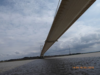
The bridge is very impressive from underneath. The cradle in the middle is for maintenance and there were a number of people in the cradle waving to us. On average, only one narrowboat a week makes this trip. When we saw how small the people looked it made you realise just how high the bridge deck is.
Two bearded sea dogs! M kept them supplied with tea, coffee and cakes.
The approach to the second ("new") road crossing is far from simple. There are rocks on either side and there is a deep depression in the seabed in the middle between the two bridges. The combination of rocks and a deep "hole" means that the water is very disturbed with eddies, strong currents and even whirlpools. To make things even more interesting, the tide does not run straight through the second bridge but at 45 degrees off to the right.
This means that to go under the middle of the centre span, you have to steer across the current almost sideways on to the bridge. M was a bit concerned to see that we were pointing in quite the wrong direction!
Carl did a great job and said to R that the trick was to judge it just right so the current carried you through the exact centre of the bridge span. He asked R to mark him out of ten; R awarded him nine and a half!
The second bridge is three miles from shore to shore and it looks amazing from underneath.
As we left the second bridge behind, MM was doing 12.5 mph. That is more than three times the speed limit on the canals and certainly the fastest she has ever gone under her own steam.
Soon, we were approaching Avonmouth and then going on a further two miles to Portishead Marina where we will moor overnight before going up to Bristol on the incoming tide tomorrow.
There is a large breakwater that protects the entrance to Portishead lock and we sheltered there while we waited for the gates to open. If we thought that Sharpness lock was big, this lock is even bigger. It even has floating pontoons inside the dock so you can tie up while the lock fills.
It is certainly the deepest lock we have ever been in at 10 metres or 32 feet! The "bottom" gates consist of two massive rotating cylinders that meet in the middle.
While we were in the lock, our pilot Carl left us and we waved him goodbye as he climbed the stairs up the side of the lock high above us. Carl did a brilliant job and we thoroughly enjoyed his company and his expert handling of MM. His last words to us were to have our camera ready as the water flow when they open the "paddles" is impressive. He was right!
The noise was deafening. But even with such a strong flow it took about half an hour to fill the huge lock.
We were given a "hammerhead" mooring on the end of a pontoon, which was excellent and included electricity - but at £48 for one night, it is the most expensive mooring we have ever had!
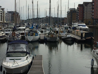
This is a very large marina that use to be a commercial harbour with a power station on one side and an industrial complex on the other. Now it is a very up-market marina but spot the narrowboat!
In MM, we had put everything from the counter tops on to the floor in case the sea caused MM to rock and roll. We also brought the flowers in from the bow deck as we thought that seawater spray would not do them any good. Everything survived very well as the sea remained very smooth with only a few waves, which MM rode well. However, M was a bit taken aback to see a small army of ants marching across the carpet from the geranium trough! Perhaps they had decided to abandon ship!
There is a Co-op in the marina, so M went to get a few more bits while R passed the time in a certain very well known coffee emporium next door; you can guess which.
An utterly tremendous and memorable day. We were both exhausted but very happy.
Today: 4 miles to Sharpness and 19 miles to Portishead, 2 (huge) locks and 4.5 hours.
Trip: 149 miles, 63 locks and 71.3 hours.


Glad you both enjoyed the trip! Safe cruising and best wishes. Carl
ReplyDelete